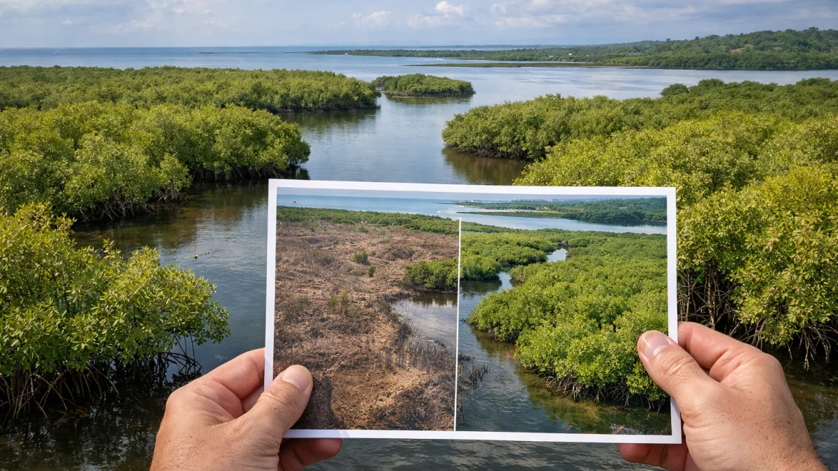
WASHINGTON — Satellite imagery has revealed a global rebound in mangrove forests after decades of decline, with gains in recent years nearly offsetting earlier losses, researchers reported.
A study published June 4 in the journal *Science*, based on four decades of NASA Landsat satellite data from 1984 to 2023, found that mangrove coverage shifted from long-term decline to expansion beginning around 2010. Gains accelerated in the past decade and have largely reversed the previous net loss trend, according to researchers from Tulane University and collaborators.
The analysis showed that while mangroves declined through much of the late 20th century due to coastal development, deforestation and other pressures, natural regeneration and conservation efforts contributed to renewed growth in many regions. Mangroves are critical for coastal protection, carbon storage and supporting biodiversity.
"Four decades of Landsat observations reveal that mangrove forest coverage shifted from long-term decline to expansion," the study authors noted, highlighting images such as those tracking growth in Malaysia's Padas River estuary between 2000 and 2023.
The findings indicate a net global decline of about 1% since the 1980s, far less than previous estimates, with expansion particularly evident in areas near river deltas and sediment-rich coastlines. Conservation measures, increased public awareness following events like the 2004 Indian Ocean tsunami, and natural propagation have supported the recovery.
Mangrove forests, which thrive in tropical and subtropical intertidal zones, provide natural barriers against storms and erosion while sequestering significant amounts of carbon. The satellite data allowed for detailed tracking of both extent and canopy health, offering a more comprehensive view than earlier assessments.
Researchers emphasized that threats including sea-level rise, pollution, storms and ongoing development persist in some areas. Specific regional variations were noted, with strong recovery in parts of Asia, the Americas and Africa, though details on exact country-level contributions continue to be analyzed.
The study used consistent global satellite observations to compile records of mangrove extent and changes. Earlier reports had documented substantial losses, but the latest data reflect improved resilience.
As of Monday, further analysis of the dataset and potential follow-up studies were underway. Scientists plan continued monitoring with satellite imagery to assess long-term trends amid climate pressures. Additional details on restoration projects and policy implications were expected in coming reports from involved organizations.